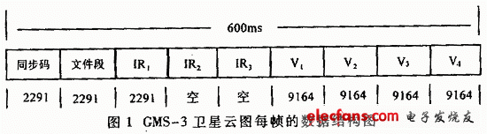
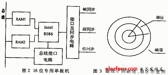
In the satellite cloud image receiving and processing system, real-time data acquisition and storage, and subsequent image processing are key technologies. The following discusses the working principle and key technology implementation methods of real-time recording and storage of GMS-3 satellite cloud image data, post-event image processing. 1 Introduction to GMS-3 satellite and its cloud image data The GMS-3 meteorological satellite is stationary above the equator at 140 degrees east longitude. The rotation speed of the satellite is 100 rpm. During the rotation, 20 degrees of cloud image data are acquired for the earth scan and 240 degrees of air scan. Cloud image data is transmitted to ground equipment. The data obtained by scanning one revolution of the satellite is called a frame, and the scanning and transmission of each frame of data can be calculated according to the rotation speed, which is (60 seconds / 100 revolutions) = 600ms. The satellite scanning stepping direction is from north to south, and the earth is scanned for about 2300 frames of data. The data structure of each frame of the GMS-3 satellite cloud image is shown in Figure 1. Each frame of cloud image data consists of 9 data segments. The synchronization section consists of 20000bit frame synchronization code, which is mainly used for frame synchronization and does not need to be saved. The IR1, IR2, and IR3 segments are infrared cloud image data. GMS-3 is only used for the IR1 segment, and IR2 and IR3 are reserved for future use. IR1 is composed of 2291 words, each word represents a pixel point scanned by a satellite, and the gray level is 256 levels. IR1 has a total of 2291 bytes of data. V1, V2, V3, V4 are visible light cloud data, GMS-3 cloud image, the resolution of visible light is 4 times that of infrared, so V1, V2, V3, V4 have data in each data segment, the number of words should be 2291+ 2291+ (9164 & TImes; 4) = 41238 bytes, about 42KB, the transmission speed is 660Kbit / s, and the amount of data scanned once on the surface of the earth is 41238 & TImes; 2300 = 94847400 bytes, about 95MB. 2 Real-time admission of cloud image data When the satellite receiver receives the high-frequency signal from the satellite, it first performs high-frequency, intermediate-frequency amplification, mediation, and decoding on it to extract cloud image data and frame synchronization pulses, word synchronization pulses, and bit synchronization pulses. Since the GMS-3 cloud image information is a 660Kbit data stream with a data volume of up to 95MB, the data sent from the cloud image receiver should be pre-processed. The main function of preprocessing is to extract and buffer the data sent by the receiver, and remove some useless duplicate data. The cloud image processing system introduced in this article is composed of an Intel 8086 CPU as the core to form a 16-bit dedicated single board computer. The interface and synchronization circuit are mainly used for frame synchronization and serial-to-parallel conversion of the signal sent by the receiver, and then store the data in the buffer memory in the manner of 16-bit DMA. The memory is divided into two parts, RAM1 and RAM2. When receiving data, first put a frame of data into one of RAM1 or RAM2, such as RAM1. When a frame of data is received and processed, the Intel 8086 CPU controls the bus interface circuit to send a data request to the host and save it The control of the RAM1 memory of the most recent frame of data is handed over to the host, while preparing for the next frame of data to be stored in another memory RAM2. With this double buffer memory method, data preprocessing can be performed in parallel with the processing of the cloud image by the host, which greatly saves the resource overhead of the host and can realize the real-time display of the cloud image. 3 Real-time storage of cloud image data Due to the large amount of data and high transmission speed of the GMS-3 satellite cloud image, the general file reading and writing method cannot complete the real-time data storage requirements, and the file organization structure of the operating system must be bypassed to directly address and read the tracks on the disk Write operation. Figure 3 shows the organization of tracks and sectors on the disk. The operating system usually performs read / write access in units of sectors, that is, read / write one sector at a time. A fan is usually 512 bytes, 0.5KB, and it usually takes 1.5ms to read and write a sector. The positioning time for the head to move between tracks, that is, the average seek time is 10ms. Assuming that the operating system needs to reposition the track after each read / write of a sector, the time it takes to store a frame of 42KB data is (42 / 0.5) & TImes; (10 + 1.5) = 966ms, which exceeds the satellite to send a frame of data The time is 600ms. If you directly control the head to a certain track in the program, and then continuously write all sectors on the track, and then look for the next empty track, assuming that each track has 17 sectors, then save 17 on one track /2=8.5KB data, it takes time (17 & TImes; 1.5) + 10 = 35.5ms. It takes about 5 tracks to save one frame of data (42 / 18.5), and the required time is 35.5 × = 177.5ms, which is much less than 600ms, which fully meets the requirements of real-time storage. 4 Main image processing functions The GMS-3 satellite cloud image is rich in information, and its images can be processed in various ways to obtain many useful materials. The following is a brief description of several commonly used main functions. (1) Add false color The GMS-3 cloud image obtained is the gray level of infrared and visible light. The gray level of infrared is 256, which is difficult for human eyes to distinguish. The infrared cloud image can be used in 8 colors, and 32 gray levels of each color can be displayed on the CRT for easy observation and analysis. (2) Roaming, zooming in and zooming out Because the panorama of the cloud image is a 2300 × 2300 rectangle, it is not easy to display on the screen at a 1: 1 ratio. Therefore, functions such as roaming, zooming, and reducing are designed in the image processing so that the global or local view of the cloud image can be observed, analysis. (3) Animation display It can continuously display multiple satellite cloud pictures at different times, from which you can see the changing process of the weather system, and can perform analysis calculations such as wind field deduction. (4) Network and landmark processing Network refers to the latitude and longitude network. The GMS-3 satellite scans and calibrates its position and attitude to obtain a set of data corresponding to the image pixels of the intersection of latitude and longitude lines. According to this set of data, grid lines of latitude and longitude can be drawn on the cloud map to improve the observation accuracy of the weather system. At the same time, the geographical location of the coastline, national borders, rivers, etc. have also been corrected. in conclusion The meteorological satellite cloud image microcomputer processing system realizes high-speed and large-capacity data processing at a relatively low cost, and satisfactorily satisfies all requirements.
Voltage range of the AC power supply is: 100~240V
The wide range makes the charger compatiable with the voltage standard in all countries. With only 15kgs, it is light weight and easy to carry.
Certificate/Conformity to standards:IEC/IECEX/CE/ROSH/IP68/ISO/EX
The combination of layers and modules is convenient and is unnecessary to use a crane for movement."
User safety, electro Enameled covered with paint and electrical protection according to their performance.
Charging Rack,Usb Charging Rack,Phone Charging Rack,Battery Charging Rack ZHEJIANG HUACAI OPTIC-TECHNOLOGY CO LTD , https://www.win3safety.com